
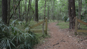
Protecting 159 acres of lushly forested bottomland along the confluence of Possum Creek and Hogtown Creek, Loblolly Woods Nature Park is an urban gem.
At this park–one of ten that make up the City of Gainesville’s Hogtown Creek Greenway–spring wildflowers carpet the forest floor and the namesake loblolly pines are some of the largest in the region.
Bisected by a broad bicycle-friendly path, it’s a place where narrow side trails lead to pretty bluffs above the creeks and sinkholes.
Resources






Disclosure: As authors and affiliates, we receive earnings when you buy through our links. This helps us provide public information on this website.
Overview
Location: Gainesville
Length: Up to 3 miles in a round-trip with loops
Trailhead: 29.654950,-82.371836
Address: 3315 NW 5th Ave, Gainesville
Fees: free
Restroom: At 5th Avenue trailhead
Land Manager: City of Gainesville
Phone: 352-334-5067
Open daily dawn-dusk. Leashed pets welcome. All trails are shared with cyclists.
Sadly, it is critical that you AND your dog stay out of the waterway, as it is terribly polluted by the time it reaches this part of Gainesville.
Directions
From Interstate 75 exit 387, Newberry Road, drive east 2.8 miles past the Oaks Mall and continue towards the University of Florida. The road becomes University Ave. At NW 34th Street (CR 121), turn left. The right turn onto 5th Avenue comes up very quickly, with a tiny sign hidden between residences. There are only three parking spaces. Alternate parking is possible farther up NW 34th Street at a city park on the right, connecting to this entrance via a sidewalk. Parking is also available at another entrance to the park off 8th Avenue on NW 31st Drive.
Hike
Leaving the parking area, walk up the path past the old environmental center and a picnic bench at the entrance to the park. This broad path is the Hogtown Greenway, a linear connector that gets a lot of use.
Where you see the fencing off to the right that looks like a little gateway ushering you down a side trail, turn right.
The trail approaches a small sinkhole in this dense bluff forest, where dogwoods bloom in late winter. There are lots of roots underfoot.
At a T intersection in the trail, a bluff overlooks the fast-moving water; you see the ripple effect in the sand bottom of the basin. The trail to the left was marked closed during our visit.
Turn right and work your way down to the water’s edge to cross the creek. At the top of the far bluff, keep left at the fork to follow the yellow blazes, simple dots on the trail.
The path is well-worn. Sizable loblolly pines tower overhead; you have to crane your head towards the canopy to see them.
The trail passes a massive Southern magnolia with a split trunk. Fungi swarms across the fallen logs.
This is definitionally an urban forest, because in every direction you’re surrounded by residential and commercial lots.
On the left is a sweeping sand bluff created by floodwaters depositing sand on a curve. Small rapids burble in the creek adjoining the trail, smooth Solomon’s seal emerging from shady spots on the forest floor.
The trail follows another bend in the creek, deeply carved from water rushing through a narrows around a horseshoe bend. Walk onto the horseshoe and see the meander of the creek around it.
It’s obvious that when it rains, floodwaters tear through this floodplain, reshaping the creek and its banks. At the next trail junction, keep left. Buildings are visible beyond the trees.
The trail reaches a peninsula where you can peer out into the residential and commercial district intersection of University and 34th Street.
Follow the trail as it curves to the right and heads up the other waterway, merging into the blue triangle blazed trail.
Keep uphill at the fork, with the side channel of the creek to the left, and left again at the junction of the yellow and blue trails, scrambling over a mass of roots.
Emerging at the stream after 0.4 mile, cross it again–it’s easier to do from this direction, using the limestone and roots as steps of a sort–and return to the Hogtown Greenway. Turn right.
This broad path tunnels through the forest, with enormous Southern magnolias overhead, before reaching the first interpretive marker along this trek, on the layers of the forest.
Another gateway on the right tempts. Turn here. There are more enormous Southern magnolias in this part of the woods, which will fill the air with sweet fragrance when they bloom in early June.
Reaching a T intersection above the creek, turn left to follow it, passing another sandy beach on an elbow in the creek.
Spaghnum moss covers the banks of a narrow point in the creek. A loblolly pine with a split trunk towers over the trail. Resurrection fern swarms over the oak limbs, lush and green after the evening’s rain.
The trail follows the creek upstream to a bench at a beauty spot. You can sit along the creek here and listen to it burble.
The trail guides you away from the creek and towards a break in the fence, another gateway to the greenway. Turn right and then left to climb to an observation deck facing a large willow marsh.
It seems to be fed by spillover from the creek during its flood stage. Tall pines line up on its fringe, elms and maples along this shoreline.
Leaving the observation deck, turn left and continue across the boardwalk, where there is a clump of needle palm at its far end. Just past it is another gateway for a walk down to the creek.
Masses of small-leaf spiderwort cover the slope. Turn left and follow the creek upstream in its floodplain. Vines grow very large here, as do many of the pines. The sand slopes down to the water.
The floodplain nature of the creek is clear here, the sand on the far bluffs is carved by water flow as if with a knife.
Another gap in the fence leads up to the greenway, but you can continue following the creek along the water’s edge, being mindful of roots and vines.
You hear the traffic from a road up ahead, which signals the edge of this segment of the park. Turn left and walk up to the next gap in the fence to rejoin the greenway.
It comes to a kiosk at the NW 8th Avenue entrance, an alternate way to access Loblolly Woods if you couldn’t find parking at the main entrance.
There is parking across 8th Avenue on NW 31st Drive, as another piece of the park continues north of 8th Avenue. At 0.9 mile, this entrance is your turn-around point.
Peek down the street and you’ll see models of the planets along the sidewalk, the Solar Walk of Gainesville.
Returning along the Hogtown Greenway, you’ll see another portal on the right into the woods, by a patch of woodlands phlox.
Follow the footpath, which is flanked with a stand of native bamboo, as you come to the largest of all of the loblolly pines you’ve seen along the trail so far.
A big swale next to the trail is dry, but can fill with floodwaters when the creek is high. The trail curves around it within sight of a water-filled sinkhole surrounded by dense forest.
Large live oaks arch over the pathway. Scattered dogwoods add a splash of color to the woods.
Turn right at the next T intersection and walk down a little ways to see the sink more closely. The trail ends here at a fence.
Turn around and backtrack under the big oaks, walking past the T intersection on a natural levee between the floodplain swale and willow marsh.
Reaching a gap in the Hogtown Greenway fence at 1.2 miles, turn right and start walking back along the greenway.
Cross the boardwalk again and pass the observation deck, taking the more direct route back through the shady woods to the trailhead to complete a 1.5 mile hike.
Explore More!
Learn more about the Hogtown Creek Greenway
 Hogtown Creek Greenway As Hogtown Creek threads its way through modern-day Gainesville, step into the past along a string of urban nature preserves.
Slideshow
See our photos of Loblolly Woods
Nearby Adventures
 John Mahon Nature Park Ten acres isn't a lot for a natural area, but at John Mahon Nature Park in Gainesville, it's plenty for a quick, refreshing walk in the woods off Newberry Road.
 Cofrin Nature Park One of Gainesville's urban nature parks, Cofrin Nature Park is right near the Oaks Mall on Newberry Rd and features a half-mile trail in a shady forest.
 Alfred A. Ring Park Featuring a dense slope forest along Hogtown Creek with old-growth trees and rare wildflowers along Appalachian-style ravines, this is a scenic hike in the heart of Gainesville.
 Devil’s Millhopper Nature Trail The Devils Millhopper Nature Trail circles the lip of an enormous sinkhole before plunging down into it on a series of staircases and landings with views of natural waterfalls.

- Baseline Trails - November 7, 2026
- Hal Scott Yellow Trail - November 3, 2026
- Hal Scott Preserve - October 28, 2026